Summit Loop
Length: 0.95 miles | Elevation Gain: 308.5 feet |
- Trailhead: Woods Creek Trailhead, North Ridge Trailhead, Meadow Edge Trailhead, Conners Camp Trailhead, Woods Creek Trailhead, North Ridge Trailhead, Meadow Edge Trailhead & Conners Camp Trailhead
- Season: Open year-round, access permitting. East Ridge, North Ridge and Tie trails closed to bicycles Oct. 15-May 15
- Hours: 24 hours
- Family Friendly: Yes
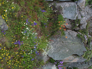
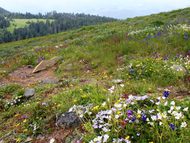
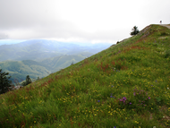
The Summit Loop, about a mile and a half in length, is a combination of gravel road and trail, taking hikers and plant enthusiasts directly to the top of Marys Peak. Starting at the parking lot, you can follow the gravel road, or the East Ridge Trail about 0.30 miles to where the Meadowedge Trail begins. At this intersection, hikers can either follow the road as it wraps around the south side of the summit, or cross the road to continue on the Meadowedge Trail to access the summit from the north. From either direction, panoramic views of the Willamette Valley and Cascade peaks abound. In the spring, rocky outcrops on the south side of the summit burst with colorful wildflowers.
TRAIL TIPS: Lorem ipsum dolor sit amet, consectetur adipisicing elit, sed do eiusmod tempor incididunt ut labore et dolore magna aliqua. Ut enim ad minim veniam, quis nostrud exercitation ullamco laboris nisi ut aliquip ex ea commodo consequat. Duis aute irure dolor in reprehenderit in voluptate velit esse cillum dolore eu fugiat nulla pariatur. Excepteur sint ocupid ratatat non proident, sunt inculpa qui officia deserunt mollit anim id est laborum.
Trail attributes
- Dogs allowed on leash
- Fee
- Hike
- Restroom
- Run
- Wildlife Watching
Know before you go:
- Dogs: Only on leash
- Site Fee: None
- Current Conditions: Lorem ipsum
- Tips: Road to site not maintained for winter travel sample link. Lorem ipsum dolor sit amet.
Photos

Siuslaw National Forest

Siuslaw National Forest

Siuslaw National Forest

Siuslaw National Forest


